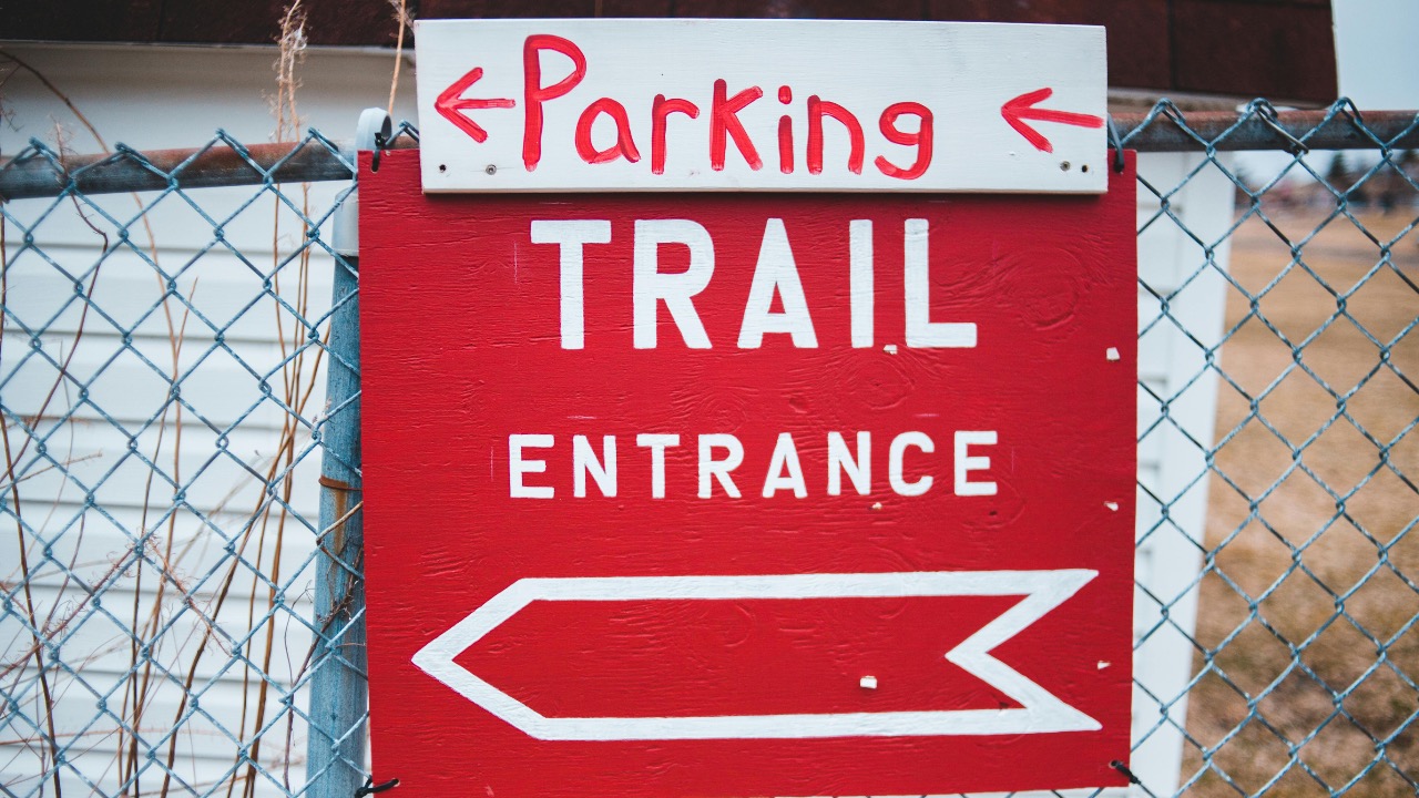
Landowner blocks “public trail”—but says it’s his private driveway
When a familiar trail is suddenly blocked by a gate and a fresh “Private Driveway” sign, the dispute that follows is rarely just about a few hundred yards of dirt. Conflicts over trailheads and access roads expose deeper questions about who owns what, how the public uses land, and how far a landowner can go to keep strangers off a property line. As more people seek out outdoor spaces and more private parcels sit between neighborhoods and public land, those questions are landing in courtrooms, city halls, and online forums.
The story behind a blocked “public trail” that a landowner insists is a private driveway sits at the center of a much larger national pattern. From Utah canal paths to California shoreline easements, from National Forest roads to suburban shortcuts, the same themes repeat: confusing deeds, historic public use, aggressive signage, and a growing reliance on digital maps to decide who is right.
When a trail becomes a “driveway” overnight
In many access fights, the conflict begins quietly. For years, hikers, runners, or dog walkers use a path that feels public. Then a new owner arrives, or an existing owner loses patience, and the route is suddenly framed as a private entrance to a home instead of a shared corridor to open space.
In Logan, Utah, city leaders are preparing to take two landowners to court over access to a canal-side route that residents have treated as a community trail. According to a public summary of the dispute, the city points first to the Paper trail, which shows that the canal corridor was never legally conveyed to the Hansen family. The same record emphasizes “Historic use,” noting that the public has long walked along the water and that the city sees no clear path to settlement without a judge deciding who controls the route.
Nearby in Logan, another conflict erupted when homeowners erected two fences across a path next to Utah State University. Those fences, covered in “private property” and “no trespassing” signs, blocked a stretch of trail that runs along a canal and connects to a golf course. Local reporting framed the core question bluntly as “Who owns the trail,” and described a roughly 1,100-foot strip of land that residents had used as a connector to longer routes.
In these fights, the landowners often describe the contested strip as part of a private driveway or yard. Neighbors and trail users see the same strip as a long-standing public trail that simply passes by a home. That difference in framing matters. A driveway implies a level of control, privacy, and liability that many owners are not willing to share. A trail implies a right of passage that users believe cannot be revoked at one person’s whim.
The legal puzzle: public use on private land
Courts have wrestled with versions of this conflict for decades. One of the clearest examples comes from California, where the doctrine of implied dedication can turn long-term public use into a legal right of way. In a key case, Friends of the Trails v. Blasius, the California Court of Appeal described how the California Supreme Court had already applied that doctrine to find public easements for recreational uses across two shoreline properties.
Implied dedication does not require a formal grant. Instead, it looks at whether the public used a route openly and continuously for a long period, often 5, 10, or more years, while the owner did not object. If those conditions are met, a court can decide that the owner effectively dedicated a trail to public use, even if no one ever recorded an easement in the county records.
That framework helps explain why cities like Logan lean so hard on both the recorded deeds and the history of public use. In the canal dispute, the “Paper trail” suggests that the canal corridor itself was never transferred into private hands, which undercuts the Hansen family’s claim that the path is part of their private driveway. The “Historic use” argument then bolsters the idea that even if some portion of the land is technically private, decades of public walking may have created a right of way that the owners cannot simply gate off.
Other areas rely less on implied dedication and more on recorded easements. A Facebook discussion about whether a public trail across private land is truly public emphasized that utility easements are not the same as a public road. One commenter noted that They are different from the public road, since those easements simply give a utility company permission to access, maintain, or repair equipment, not to invite hikers or dog walkers.
That distinction is central when a landowner calls a path a driveway. A driveway that sits on a recorded private parcel, with no public easement, is generally under the owner’s control. A driveway that overlaps a public right of way, or a corridor that has become a public easement through long use, is something else entirely.
How landowners quietly shut the gate
Access conflicts rarely start with a lawsuit. They begin with small, tactical steps that are easy to miss until a trail is functionally gone. Outdoor advocates have cataloged a familiar set of tactics that some owners use to discourage or block the public from reaching public land that sits behind private parcels.
One analysis of access conflicts described at least seven “sneaky” tactics that owners use to keep hunters, anglers, and hikers away from public parcels. The list included locked gates on shared roads, misleading signs that suggest a public easement is entirely private, and fences that extend just far enough to make passage feel risky or illegal. The same piece warned users not to retaliate by ripping down signs or plowing through fences, and instead urged them to follow a section titled “What Not to Do,” which advised, “Do not plow through the fence or rip down the sign. This simply invites more conflict. Channel that energy into documenting the problem and contacting agencies.”
That advice hints at a broader pattern. Owners who want to reframe a trail as a driveway often start by saturating the area with “Private property” and “No trespassing” signs, even along segments where the legal status is contested. In one Substack essay about trail access, the writer described how an orange line on a map showed the official public trail, yet a cluster of PRIVATE PROPERTY signs and constant surveillance at the edge of a neighborhood made most people believe the trail ended at the first fence.
Sometimes owners install cameras or park vehicles in ways that narrow the corridor, creating the impression that walkers are intruding on a driveway. A path that once felt like a shared lane to the woods starts to feel like someone’s front stoop. That psychological shift can be as effective as a locked gate.
Digital maps, purple paint, and who owns what
As more disputes surface, people are increasingly turning to digital tools to resolve them. A Facebook discussion about a “Private property” sign on Kings Crown Road in a National Forest captured this trend. One commenter argued that OnX is a great tool to see exactly where someone is standing and who owns what, noting that Hunters use it all the time as lands change ownership.
Apps like OnX, Gaia GPS, and county GIS portals have turned parcel lines into something that anyone with a smartphone can check. Yet those lines do not always answer the key question in a driveway-versus-trail dispute. A parcel map might show that a strip of land is privately owned, but it may not display recorded easements, historic rights of way, or implied dedications created by decades of public use.
In Vermont, a commentary on the state’s “purple paint law” argued that it should not even take boundary markings to understand property lines, given the availability of low-cost apps that display ownership and what the writer described as GIS data. The author suggested that better digital information could reduce confusion about where public rights end and private control begins.
At the same time, some landowners see digital maps as a threat. If an app shows a thin public corridor between two private parcels, more people may try to use it. In response, owners sometimes mark trees with purple paint, add extra “No trespassing” signs, or post handwritten notices that describe a shared access road as a private driveway, hoping to deter anyone who is not absolutely certain of the legal status.
Online arguments, real-world stakes
Few issues ignite local comment sections faster than a blocked trail. The Logan canal dispute drew a stream of comments from residents who insisted that the public had always walked there, and from others who defended the Hansen family’s right to control what they saw as their land. Some commenters mocked the lack of a clear map in early coverage, accusing “Reporters these days” of being sloppy. Others pointed out nearby buildings and golf course routes that, in their view, showed how years of informal decisions had led to the current standoff.
Elsewhere, Reddit threads and advice columns capture the same tension from different angles. One Reddit user asked whether they would be wrong to block off access to their land that locals used to reach trails. The top advice suggested that the owner should Post a clear private property sign with a warning that the property was no longer open to those wishing to pass through, and reassured the poster that they were NTA, or “not the asshole,” for wanting control of their land.
Another Reddit discussion in an Appalachia forum asked how private landowners were managing to bar people from public lands that sit behind their parcels. One commenter floated a scenario in which someone could buy any private property that abuts a national forest road, throw a gate across it, and declare that no one could use it. That hypothetical mirrors real disputes where a narrow strip of private land controls the only practical route to a large block of public land.
On Quora, a user described a different problem: authorities who mistakenly believed that a private parcel was part of a public park and allowed public access. A respondent, who identified as a Former SAT &, warned that the owner might have a bigger problem than just foot traffic. Unless the owner was in possession of clear legal documents, they risked being treated as if they had tried to steal someone’s land.
These online debates underscore a basic reality. For hikers and bikers, the blocked path is about convenience, recreation, and sometimes safety. For landowners, it is about liability, privacy, and the fear that informal use today could ripen into a permanent public right tomorrow.
Public agencies caught in the middle
Local governments and land management agencies often find themselves stuck between angry landowners and equally angry trail users. In Logan, city leaders have moved toward litigation because informal negotiations with the Hansen family and other owners have stalled. Officials there argue that the canal corridor was never conveyed to the family and that the public’s long use of the path justifies a formal right of way.
Legal scholars who study access conflicts note that private parcels can create both physical and legal barriers to public land. One analysis of access policy observed that Private lands create access barriers and impediments to public access to adjacent public lands, both literally and legally. In many western states, checkerboard ownership patterns leave public parcels landlocked behind private ranches, with no recorded easements to reach them.
When a trail that crosses private land becomes a regional asset, agencies sometimes try to negotiate easements or purchase narrow corridors outright. That can be expensive and politically fraught, especially if owners feel that years of informal public use have already eroded their control. In some cases, agencies back away from conflict and quietly reroute trails, which can validate an owner’s decision to treat a long-used path as a private driveway.
Other times, public pressure pushes agencies to act. In the Logan canal case, residents have argued that the city should defend access aggressively, pointing to the Paper trail and Historic use as reasons to fight. Similar pressure has surfaced in suburban neighborhoods where residents share photos of new fences and signs on social media, tag local officials, and demand a legal review of who actually owns the contested strip.
How “PRIVATE PROPERTY” signs shape behavior
Signage does more than mark boundaries. It shapes how people interpret ambiguous spaces. The Substack essay about trail access described a clear example: the official map showed the public trail as an orange line that continued past a cluster of homes, but a gauntlet of Who Owns Public style warnings and PRIVATE PROPERTY signs convinced most casual users that they had reached the end.
Psychologically, few people are willing to walk past a prominent “No trespassing” sign, even if they suspect that a legal easement exists. Owners know this. Some place signs at the very edge of their property, or even slightly into public land, to maximize the chilling effect. Others add language about video surveillance, guard dogs, or liability, which makes the area feel even less like shared space and more like a private driveway.
The color and format of markings also matter. In states with purple paint laws, vertical stripes on trees or posts carry the same legal weight as a “No trespassing” sign. That system can help owners who want to mark long rural boundaries without buying hundreds of metal signs. It can also confuse visitors who do not know the law and assume that an unmarked path is open, while a painted tree off to the side might actually define the legal line.
When an owner wants to convert a trail into a driveway in the public mind, the sequence is often the same. First, add a gate or chain across the path. Second, cluster “Private property” and “No trespassing” signs at eye level. Third, park a vehicle or place landscaping elements that visually narrow the corridor, so anyone walking through feels as if they are squeezing past someone’s front bumper. Over time, fewer people test the route, and the owner can argue that public use has diminished, which might matter in an implied dedication analysis.

Leo’s been tracking game and tuning gear since he could stand upright. He’s sharp, driven, and knows how to keep things running when conditions turn.