National Oceanic and Atmospheric Administration Warns of Increased Hurricane Risk This Season
The National Oceanic and Atmospheric Administration is warning coastal communities that the coming Atlantic hurricane season carries a higher-than-usual risk of intense storms. After several years of destructive landfalls and rapid intensification events, forecasters now expect another busy stretch of tropical activity that could test homes, power grids, and emergency systems across the basin.
The alert rests on a mix of warm ocean waters, evolving El Niño conditions, and a recent track record of very damaging cyclones. Taken together, those signals suggest that residents from the Gulf Coast to the Eastern Seaboard should treat this season as a serious threat and move early on preparedness rather than waiting for the first named storm.
Why NOAA sees an above normal season taking shape

Forecasters at NOAA say the Atlantic is primed for more storms than usual, with particular concern about the likelihood of stronger systems. In a recent seasonal outlook, NOAA highlighted a 60% chance that the upcoming Atlantic season will be above normal, compared with only a 30% chance of a near-normal year, reflecting growing confidence that environmental conditions will favor storm formation. That assessment, shared through an update on the NOAA outlook, frames the risk in clear statistical terms that emergency managers can use for planning.
The agency has also reaffirmed that its earlier call for an above normal Atlantic hurricane season remains on track, indicating that the latest data on sea surface temperatures and atmospheric patterns has not eased concern. In its update on the prediction remains on, NOAA stresses that warm waters and supportive wind patterns are still in place, which historically correlate with more frequent and more intense storms. For coastal communities that have already endured several active years, that continuity in the forecast is a clear prompt to assume another demanding season rather than hoping for a late shift toward calmer conditions.
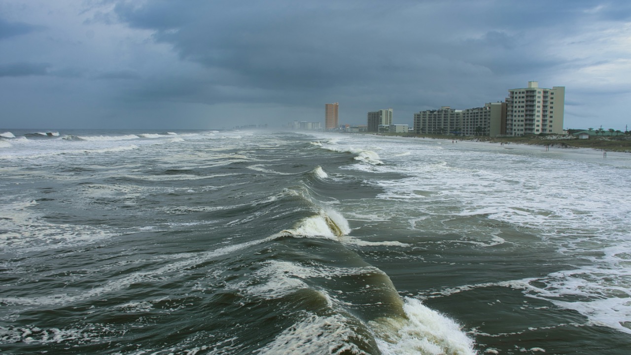
Recent seasons show what an “above normal” forecast really means
The phrase “above normal” can sound abstract, but recent Atlantic seasons have given it very concrete meaning. The National Hurricane Center’s official tropical cyclone reports for 2024 in the Atlantic basin document a series of storms that intensified quickly, produced destructive surge, and generated large swaths of inland flooding. That record shows not just a high storm count but also a pattern of hurricanes reaching major status over unusually warm water, a trend that leaves less time for coastal residents to react when a system suddenly strengthens near land.
The destructive potential of a single powerful storm is also on display in the case of Hurricane Melissa, which is now tied for the strongest on record in the Atlantic basin. Reporting on Hurricane Melissa describes maximum sustained winds that match the top tier of historical storms, along with satellite imagery that tracks Melissa’s full journey through the Atlantic. That kind of intensity, layered on top of already elevated sea levels, turns an “active” forecast into a real-world threat that can reshape coastlines and communities in a matter of hours.
El Niño, ocean heat, and the science behind the warning
Behind NOAA’s warning is a set of physical drivers that scientists can measure months before the first named storm. One of the most closely watched signals is El Niño, the recurring pattern of warmer-than-average waters in the central and eastern Pacific that can influence wind patterns over the Atlantic. According to the Climate Prediction Center, NOAA suspects that El Niño will reappear in time for hurricane season, with the February outlook indicating that the waters should reach the threshold that defines El Niño and could, depending on how the atmosphere responds, either increase or decrease storm numbers. Coverage of this forecast explains that the El Niño signal might still allow for a bad season if other ingredients, such as Atlantic warmth, are strong enough.
Warm Atlantic waters are already a major concern. Long-range outlooks for the 2026 Atlantic hurricane season, including early analysis that describes a potential “hyperactive season,” point to sea surface temperatures that remain well above long-term averages in key development regions. One such forecast notes that while NOAA has not yet released its official 2026 numbers, the combination of strong winds, rapid intensification, and high ocean heat content seen in recent years has raised alarms about what could happen if similar conditions return. That perspective is reflected in an early Atlantic hurricane outlook that ties potential storm behavior to both climate trends and the need for reliable backup power when grids are stressed by landfalling systems.
How the 2026 Atlantic hurricane season is already being framed
Even before the official start of the season, meteorologists and climate watchers are already discussing how 2026 might unfold. An early social media outlook from Feb notes that the 2026 HURRICANE SEASON is now 100 days away and describes the early expectation that storm numbers will be closer to average or slightly above average. That commentary, which stresses “no hype, just the facts,” frames the 2026 Atlantic Hurricane Season as one where even a near-average count can be dangerous if a few storms track into populated coastlines, a point repeated in a related post that states “100 Days until HURRICANE SEASON 2026 As of Today February 21, 2026, we are officially 100 days away from the start of the 2026 Atlantic Hurricane Season.” The latter message, shared in a Herald-Tribune update, anchors the sense of a countdown that leaves little time for complacency.
Formal outlooks are also beginning to line up. The 2026 Atlantic hurricane season is already the subject of detailed discussion, with seasonal prediction groups examining how sea surface temperatures and atmospheric patterns might shape activity. According to an overview of the 2026 Atlantic hurricane, research teams are evaluating how North Atlantic sea surface temperatures (SSTs) and other climate signals could influence the number and strength of storms. These early technical assessments, while still subject to change, align with NOAA’s broader message that the Atlantic remains in a period of heightened risk, even if individual year-to-year counts fluctuate.
Preparedness, early warnings, and the push for resilient power
As NOAA raises the alarm about increased hurricane risk, attention is turning to how well communities can absorb another active season. Efforts such as the global initiative for early warnings for emphasize that timely alerts and clear communication can sharply reduce casualties, but only if residents know how to act on that information. In the United States, the Department of Commerce, which oversees NOAA through its leadership role described on the Commerce Department site, is pushing for better integration of forecast data into local planning, from evacuation routes to building codes that can withstand higher winds and surge.
Households and businesses are also rethinking how they handle extended power outages that often follow landfalling hurricanes. With forecasts hinting at a potentially hyperactive stretch and the memory of storms like Hurricane Melissa fresh in mind, interest is growing in whole home backup systems that can keep critical devices online when the grid fails. Companies that focus on resilient energy, such as those promoting whole home backup and dedicated whole home generator setups, are positioning battery-based systems as an alternative to traditional fuel-powered generators. Specific products like the DELTA Pro Ultra X, highlighted in Delta Pro Ultra marketing and a related Delta Pro Ultra listing, are being pitched to homeowners who want days of backup capacity without relying on gasoline deliveries that can be disrupted by blocked roads and damaged ports.

Leo’s been tracking game and tuning gear since he could stand upright. He’s sharp, driven, and knows how to keep things running when conditions turn.