The storm patterns meteorologists say are becoming more dangerous
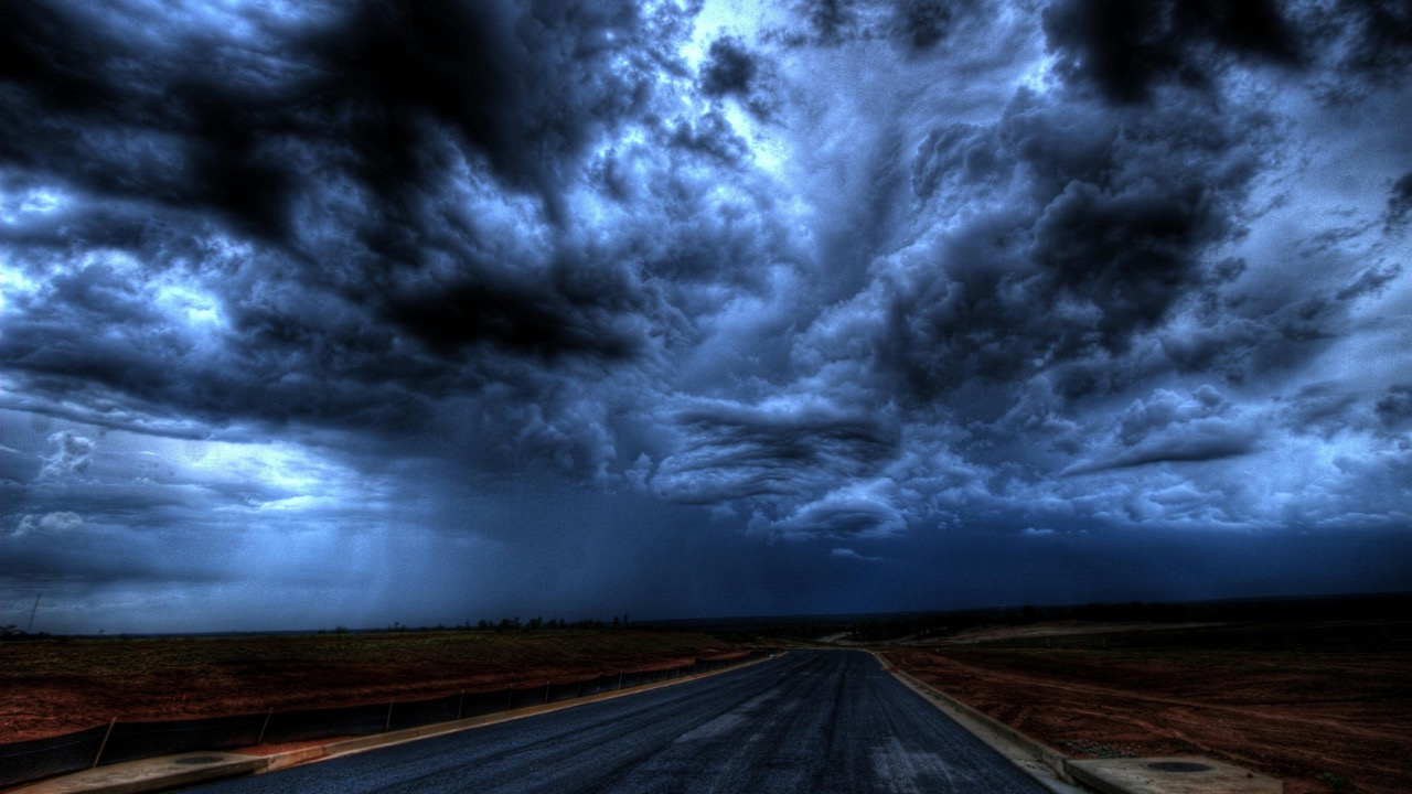
From record-breaking winds in Caribbean hurricanes to flash floods that turn city streets into rivers, the storms people face are changing faster than many communities can adapt. Meteorologists describe a world where familiar systems like hurricanes, tornadoes and thunderstorms are tapping into extra heat and moisture, turning once rare extremes into more regular threats. The patterns are shifting, and the risks are rising with them.
Scientists now link these shifts directly to a warming climate and to the ways cities and coasts have been built. The result is a new generation of dangerous weather: wetter hurricanes, longer heatwaves, more intense downpours and rapid swings from drought to flood that leave little time to prepare.
The climate signal behind more violent storms
Across the globe, researchers point to a consistent driver behind the changing behavior of storms: a hotter atmosphere and ocean. Global Climate assessments describe how human influence has already altered extreme weather in every inhabited region, with more intense heatwaves, heavier rainfall, longer droughts and stronger tropical cyclones. Warmer air holds more water vapor, which feeds heavier downpours, while warmer seas provide extra fuel for hurricanes and cyclones.
That connection is visible in disasters from deadly wildfires in California to devastating floods in North Carolina. Analysts explain that climate change is, storm surge and rainfall rates, which raises the odds that coastal storms will overwhelm defenses and that inland systems will trigger catastrophic flooding. At the same time, the loss of forests, wetlands and other natural buffers removes some of the protection that once softened those blows.
New analysis of satellite and observational records backs up what residents already sense. Data highlighted by The Royal Meteorological Society show a dramatic rise in the intensity of weather events, along with more frequent jumps from one extreme to another, such as rapid switches between heavy rain and dry spells. The Royal Meteorological Society has warned that these sudden transitions can cause more harm than any single event because people, infrastructure and ecosystems are left with no recovery time between shocks.
Hurricanes that hit harder and flood farther inland
Among the clearest examples of shifting storm risk are tropical cyclones in the Atlantic and other basins. Scientists who contribute to global assessments say that strong hurricanes are now more likely than they were a century ago, and that large storms are becoming both more intense and more frequent. One analysis finds that major hurricanes have increased in number compared with conditions 100 years ago, with warming seas playing a central role.
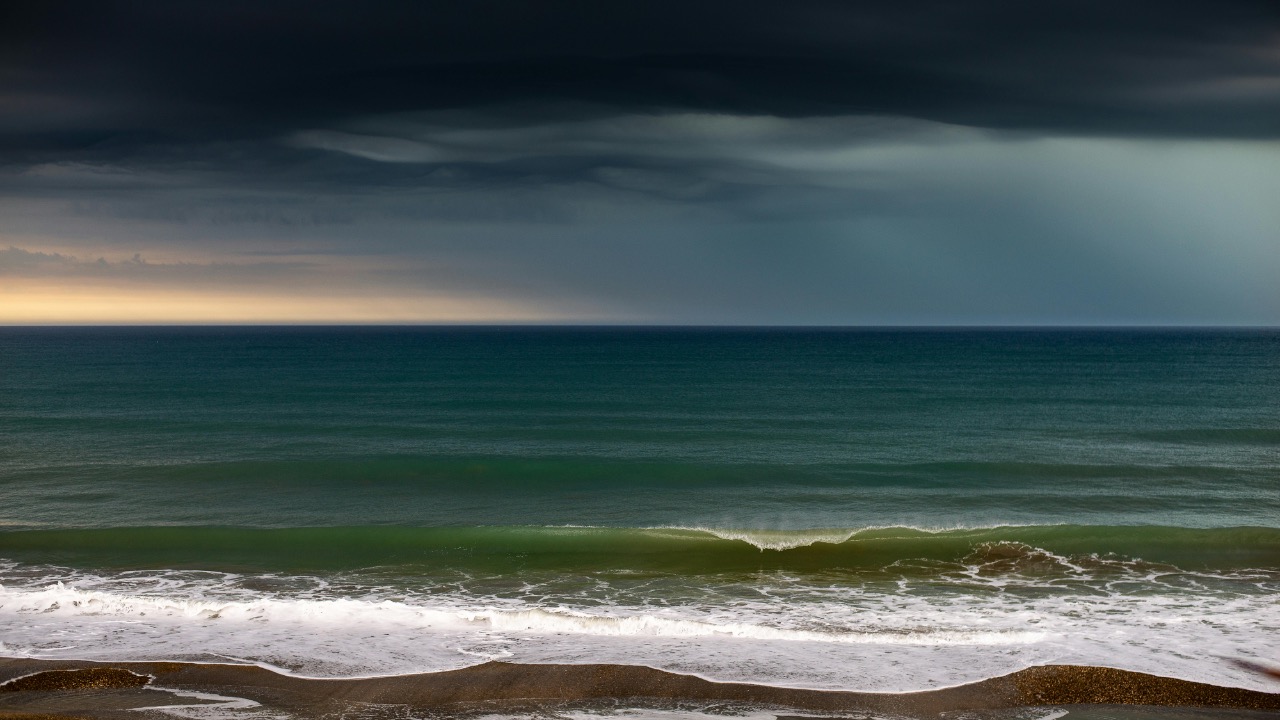
Research on coastal impacts shows that it is not just wind speed that makes these storms more dangerous. Warmer oceans and rising sea levels are combining to raise the baseline for flooding. A higher ocean surface gives storm surge a head start, while extra heat in the water column allows hurricanes to pull more energy and moisture into their cores. That combination increases rainfall rates inside the storm. Studies of recent landfalling systems, including Hurricane Ian, have concluded that climate change infused storms with significantly more rain than they would have produced in a cooler world.
Climate scientists and disaster analysts describe how a warmer climate supercharges the atmosphere, which in turn fuels stronger hurricanes that are more destructive and costly for U.S. communities. One assessment of Climate Change finds that climate change fueled hurricanes are increasingly destructive and costly for U.S. communities, with higher storm surge, heavier rain and longer lasting damage.
Storm surge itself is drawing more attention from coastal planners. Surge occurs when strong winds push water toward the shore, piling it up against the coast. Rising sea level and stronger hurricanes mean that surge can now reach farther inland and to higher elevations than in the past. Analysts who study why storm surge is dangerous warn that as seas rise, more communities may become increasingly at risk from coastal flooding that used to be confined to a narrow strip along the beach.
Storm surge, sea ice loss and coastal vulnerability
In polar regions, the loss of sea ice is changing how storms interact with shorelines. As Arctic sea ice declines, open water stretches farther, allowing waves to build more energy before they reach land. Researchers monitoring this shift explain that in conjunction with sea ice loss, things like rain storms and wind are likely to become more frequent and intense. Within these evolving systems are very real threats to coasts, because stronger waves and higher water levels can be dangerous for coastal civilizations and ecosystems.
Along more temperate coasts, the story is similar. Rising seas, subsiding land and the spread of development into low lying areas have created a larger zone of exposure. National hurricane centers now provide detailed storm surge maps to show how even a category 1 or 2 storm can produce life threatening flooding in some locations. Those maps draw on the Saffir Simpson Hurricane Wind Scale, which classifies storms by wind speed but is now paired with separate surge and rainfall warnings to capture the full hazard.
Scientists who track these trends emphasize that coastal risk is not solely a function of physics. Decisions about where to build homes, roads and industrial sites, and about how to manage wetlands and dunes, either amplify or reduce the damage when high water arrives. That is why many experts now argue for pairing emissions cuts with aggressive adaptation, from elevating structures to restoring natural buffers.
Tornado seasons that are longer, less predictable and more crowded
Far from the coasts, meteorologists are watching another pattern shift: the behavior of severe thunderstorms and tornadoes. In the central United States, the traditional spring peak of tornado activity is starting to blur, with more events in what used to be quieter months. Some studies suggest that the region of highest tornado frequency is also expanding eastward into more densely populated areas.
Forecasters describe how, under the climate change scenario, the atmosphere is being supercharged on some days and then made less favorable on others. In an interview about severe weather risk, one expert explained that Under the climate change scenario, the atmosphere on some days has more energy and moisture, which can support more intense tornado outbreaks when conditions line up. On other days, shifts in wind patterns may suppress storm formation. The result is fewer average days with storms but a higher risk of explosive events when ingredients combine.
Seasonal forecasts already reflect this concern. In one outlook, meteorologists warned that during the first half of May, the bulk of the severe thunderstorms and tornadoes would likely focus on the nation’s midsection, including states that have seen repeated outbreaks in recent years. They described a dangerous pattern that could escalate as warm, humid air interacts with strong upper level winds. The same forecast stressed that the danger would be highest when the conditions are right for organized storm systems. That warning came in a discussion of how During the first half of May, the pattern would favor repeated severe weather episodes.
At the same time, the number of trained meteorologists staffing some local offices and small market television stations has fallen, which can slow warning communication. That combination of more volatile storm environments and thinner forecasting capacity has emergency managers worried about missed alerts and communities caught off guard.
Thunderstorms turbocharged by cities
Another subtle but significant shift involves how urban areas influence thunderstorms. Researchers studying storm behavior over and around large cities have found that urban environments can alter the trajectory and intensity of warm season storm systems. Heat from buildings and pavement, along with the roughness of the urban skyline, can cause air to rise more vigorously, which can intensify storms or change where they drop their heaviest rain.
One research team concluded that this means that warm season thunderstorm systems will probably increasingly lead to more flash flooding, which can be very dangerous in built up areas. Their work on how cities incite thunderstorms showed that urban environments alter the behavior of storms, steering them toward or around city centers and sometimes enhancing rainfall rates downwind.
These findings have direct implications for stormwater systems. Many drainage networks were designed for rainfall patterns that are already out of date, based on historical averages that did not account for a warmer atmosphere or the added lift from urban heat islands. When storms stall over a city or repeat over the same corridor, under capacity sewers and culverts can quickly back up, flooding basements, subway lines and underpasses.
Rapid swings between extremes
Perhaps the most unsettling pattern meteorologists describe is not a single type of storm, but the way different extremes are now linked. Long, hot dry spells that parch soil and vegetation can be followed by intense downpours that the land can no longer absorb. This creates a setup where flash floods rip through areas that were in drought only weeks before.
NASA data, highlighted by The Royal Meteorological Society, reveal that the intensity of both wet and dry events has increased, and that the swings between them are becoming more abrupt. The Royal Meteorological Society warned that such sudden transitions from one extreme to the other cause more harm than the individual events would on their own, because systems that have been stressed by drought are more vulnerable to erosion and runoff when heavy rain finally arrives.
Climate attribution studies now routinely link specific events to global heating. In one summary shared on social media, researchers described how the record breaking 252 mph winds of Hurricane Melissa that devastated Caribbean islands at the end of October were made five times more likely by the climate crisis. The same analysis found that scorching wildfire weather in Spain and Portugal during the summer was made 40 times more likely, while June’s heatwave in England was made 100 times more likely. The commentary concluded that what can now be shown is that this warming produces record heatwaves and more violent storms with increasing frequency, and that adaptation experts think about how to reduce the risks to life from such events all the time.
Cyclones on new tracks and regional warnings
Outside the Atlantic, similar concerns are surfacing in the South Pacific. Meteorologists in New Zealand have warned that cyclone risk near the country is rising in 2026, with regions told to prepare now. They point to warmer ocean temperatures and shifting atmospheric patterns as the main drivers. In their briefing on What Driving the describe how warmer seas to the north and northeast of New Zealand can support more intense systems that track closer to the country, even if they transition to extra tropical storms before landfall.
These warnings echo broader findings that tropical cyclones are already affecting a wider range of latitudes. As sea surface temperatures rise, the zone where storms can maintain strength expands, which raises the odds that places with limited experience of direct hits will face damaging winds and flooding. For countries with aging infrastructure or limited emergency management capacity, even one such event can have long lasting consequences.

Leo’s been tracking game and tuning gear since he could stand upright. He’s sharp, driven, and knows how to keep things running when conditions turn.