Winter storm warnings issued as heavy snow and strong winds approach
Winter weather is surging back into the headlines as forecasters warn of heavy snow and damaging winds across parts of North America and Europe. From the northern Plains and Great Lakes to the Alps and the high country of Spain and Germany, travel and daily routines are bracing for fresh disruption as late season storms tap Arctic air and strong jet stream energy.
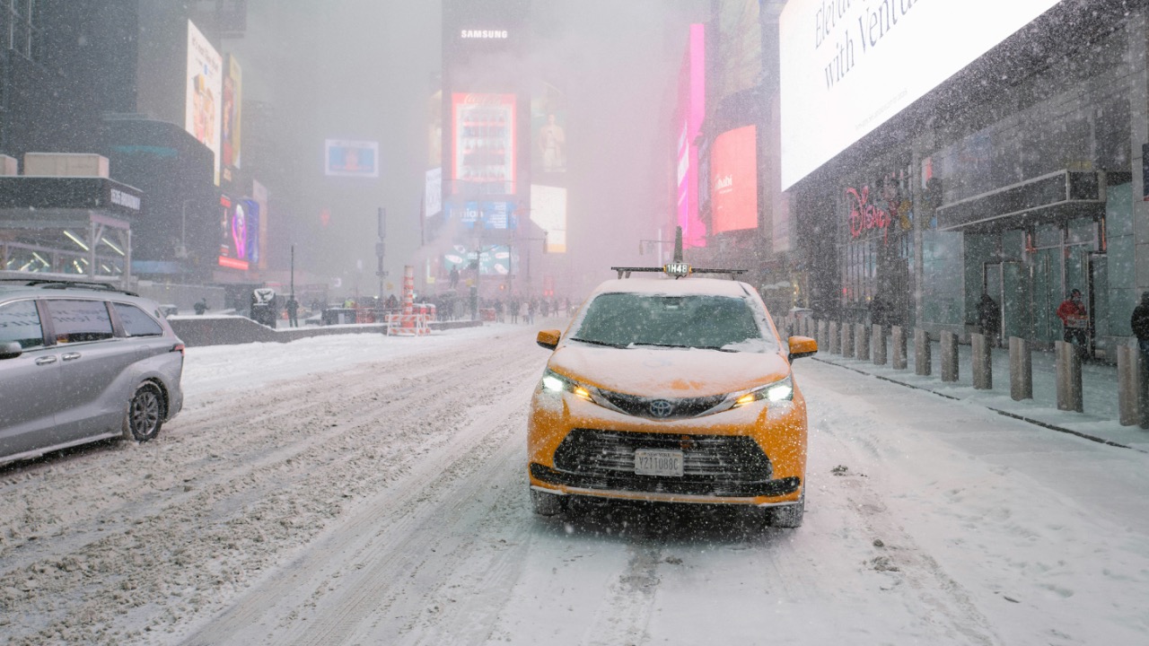
Officials are issuing winter storm and blizzard alerts that reference recent historic events, including a March system that buried parts of the Upper Midwest and another that produced snowfall rates of 2.5 to 7.5 centimeters per hour. With gusts that can reach highway speeds and snow totals measured in feet, the coming days will test infrastructure, emergency services and household preparedness across multiple regions.
Warnings expand across the northern United States and Canada
Forecasters in the northern tier of the United States are tracking a deepening low pressure system that will pull moisture north from the central Plains and wrap it into cold air spilling south from Canada. The setup is classic for a March blizzard, with strong temperature contrasts along the storm’s front and a vigorous upper level disturbance providing lift.
Guidance from earlier this month already showed how quickly such a system can intensify. One analysis described a major winter storm that brought blizzard conditions from eastern South Dakota into northern Michigan, with snowfall rates of 2.5 to 7.5 centimeters per hour as the storm intensified. That event shut down stretches of interstate, stranded drivers and forced airlines to cancel hundreds of flights as visibility dropped to near zero in whiteout conditions.
In the new round of warnings, meteorologists are emphasizing the combination of heavy snow and wind rather than snow totals alone. Some alerts reference gusts that could approach 100 miles per hour along exposed ridges and coastal headlands, a speed more commonly associated with a weak hurricane than a typical winter storm. That wind threat is why agencies are leaning on blizzard criteria and urging residents to prepare for power outages and tree damage even in areas that receive less snow.
Great Lakes and Upper Midwest recall a historic March storm
Communities around the western Great Lakes and Upper Midwest are still cleaning up from a historic March storm that offers a clear preview of what the next system could deliver. In an official Overview, meteorologists described how a powerful winter storm moved into the Upper Midwest Saturday evening, then continued to affect the region through Monday with intense snow bands and strong winds.
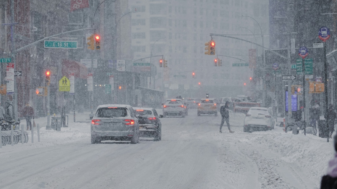
Farther north, another office chronicled how that same storm produced a brief lull in snowfall Sunday evening. After that pause, heavy snow redeveloped from south to north early Monday morning, catching some travelers off guard as conditions deteriorated again. Transportation officials in Wisconsin leaned on highway cameras and social media to show near whiteout conditions and urged drivers to stay off the roads until plows could regain control of drifting snow.
Parts of neighboring Minnesota and Michigan also saw travel grind to a halt as snow packed onto highways and rural routes. As the next storm approaches, those same regions are again under winter storm or blizzard watches, with forecasters warning that fresh snow on top of existing drifts will make rural travel particularly hazardous. The memory of that earlier event is helping officials communicate the risk, since residents have a very recent reference point for how quickly conditions can slide from manageable to dangerous.
Blizzard Warnings and what they really mean
Many residents see the word “blizzard” in a forecast and focus on snowfall totals, but official criteria are more focused on wind and visibility. According to federal winter weather guidance, Blizzard Warnings are issued for frequent gusts greater than or equal to 35 m per second accompanied by falling or blowing snow that reduces visibility. That combination can create life threatening conditions even if total accumulation is modest.
Under those criteria, a relatively light snowfall can still trigger a blizzard alert if strong winds pick up loose powder and create ground blizzards that obscure roads and landmarks. This is why forecasters are stressing that people should not fixate on the exact number of inches in the forecast, but instead on whether they will need to travel during the period of strongest wind and lowest visibility. Wind chill is another concern, since strong gusts can drive apparent temperatures well below freezing and increase the risk of frostbite for anyone caught outside without proper gear.
In mountainous regions, such as the high terrain of the Northeast or the Rockies, blizzard criteria can be met even when lower elevations see only a rain snow mix. One recent set of warnings for six states highlighted that Blowing snow will significantly reduce visibility at times, with periods of zero visibility. They added that travel to the Summits would be extremely dangerous or impossible during peak conditions, a reminder that hikers and backcountry skiers face different risks from drivers on plowed highways.
Europe faces its own late season winter blast
The late season pattern is not limited to North America. Across Europe, a sharp Arctic outbreak is poised to reverse an early taste of spring and bring fresh snow to low and mid elevations. Meteorologists tracking a deep trough describe a Polar vortex lobe dropping south that will unleash an Arctic polar plunge across the continent. In one detailed discussion, the section labeled What is this? explains how the sharp temperature change behind the Polar front and the persistence of the cold pool will keep conditions wintry long after trees have begun to bud.
In the Alps, forecasters are already calling for significant new accumulation. A recent Weather & Snow noted that Over 1 meter of fresh snow is possible by Sunday morning in some parts of the Alps, especially on north facing slopes that benefit from the incoming flow. That kind of late season dump is good news for ski resorts in regions such as the Aosta Valley, which rely on consistent snow cover to extend their seasons into spring holidays.
Farther west and south, a separate alert describes a Mar event under the banner Late Season Winter Blast, with Germany and Spain Brace for Polar Front and Snow. In that outlook, the Polar Front in Spain is expected to drop snow levels closer to major cities, prompting the national agency AEMET to place Spain on alert for strong winds, coastal impacts and potential late season snowfall. Similar concerns extend into central Europe, where Germany faces a mix of heavy rain, wet snow and rapidly falling Temperatures that could turn untreated roads icy within hours.
United Kingdom and Ireland watch the storm track
In the British Isles, forecasters are watching how the same Arctic plunge interacts with Atlantic systems. A regional outlook for the week ahead in late Mar describes a more unsettled pattern replacing the fine and often sunny weather of the previous week. The presenter acknowledges that some viewers might be tired of the dry spell and ready for change, but cautions that the new pattern will bring stronger winds, colder air and a greater risk of hill snow.
Local coverage from central England reinforces that message. One report on weather maps for the Midlands notes that Temperatures are set to plummet over the coming days, with a snow system heading for the region overnight into Monday. The article, written by Richard Guttridge Agenda Editor, explains how a low pressure center will slide across England and allow colder air from Scotland and the north to undercut milder Atlantic moisture.
For residents, that means a messy mix of rain, sleet and wet snow at lower levels, with heavier accumulation on higher routes such as the Pennines and Scottish Highlands. Authorities are advising drivers to check conditions before crossing exposed passes and to be prepared for rapidly changing visibility, especially after dark when temperatures drop below freezing and refreeze any daytime meltwater.
High winds, deep snow and the risk to travel
Across both continents, the combination of heavy snow and strong winds is the main threat to travel and infrastructure. In North America, one analysis of a major March storm highlighted how Snowfall rates of 2.5 to 7.5 centimeters per hour from eastern South Dakota into northern Michigan quickly overwhelmed plow crews. When those bands coincided with gusts over 60 miles per hour, visibility plunged and even four wheel drive vehicles struggled to stay on the road.
In mountainous regions and high plateaus, warnings are even more stark. One bulletin about winter storm warnings announced for six states emphasized that Blowing snow will significantly reduce visibility at times, with periods of zero visibility. They stressed that travel to the Summits would be extremely dangerous, since winds tend to accelerate over ridgelines and funnel through passes, creating localized gusts well above those recorded in nearby valleys.
Urban areas are not immune. Heavy, wet snow can cling to power lines and tree branches, which then become vulnerable when strong gusts arrive. In coastal regions, the same storm that produces inland snow can also generate large waves and coastal flooding, especially when it coincides with high tide. Emergency managers are urging residents to secure loose outdoor items, park vehicles away from large trees and keep mobile devices charged in case of power cuts.
Safety guidance as conditions deteriorate
With winter storm warnings in effect, safety organizations are repeating familiar but often ignored advice. Roadside assistance experts at AAA recommend that anyone who must drive in severe winter weather Keep a bundle of cold-weather gear in the car. That kit should include extra food and water, warm clothing, a glass scraper, blankets, medications and other essentials that would allow occupants to stay safe if they become stranded.
Authorities also advise slowing down well below posted speed limits, increasing following distance and avoiding sudden braking or acceleration that can cause skids on snow packed or icy surfaces. Where possible, residents are urged to postpone nonessential travel until after plows have treated major routes and winds have eased. For those who rely on public transit, agencies may run reduced schedules or suspend service on exposed lines, so checking for updates before leaving home is critical.
At home, basic preparations can make a significant difference. Stocking several days of nonperishable food and bottled water, ensuring that flashlights and battery powered radios have fresh batteries, and charging backup power banks can help households ride out short term outages. In areas where natural gas or electric heating is vulnerable, some residents are turning to wood stoves or portable generators, although experts stress that generators must be operated outdoors and away from windows to prevent carbon monoxide buildup.
Looking beyond this storm
While the immediate focus is on the approaching system, meteorologists are already watching the broader pattern into early spring. The same trough that is driving Arctic air into Europe and North America may relax in the weeks ahead, allowing milder air to return. One outlook tied to the six state warnings notes that, according to NOAA, warmer weather is ahead once the current storm cycle breaks down.

Leo’s been tracking game and tuning gear since he could stand upright. He’s sharp, driven, and knows how to keep things running when conditions turn.