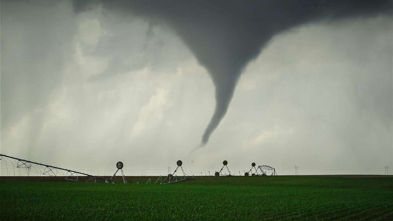
Tornado watch issued in parts of the Deep South as western storms intensify
A swing in the weather pattern over the United States has put parts of the Deep South on alert. A tornado watch has been issued for areas including the Florida Panhandle, southern Georgia, Alabama and parts of Mississippi as a potent storm system pushes eastward across the Southeast. These watches are issued when atmospheric conditions favor the formation of tornadoes and severe thunderstorms—meaning supercell thunderstorms could develop, pack damaging winds, hail and even spin up brief tornadoes.
Meanwhile, in the West, strong storms are brewing with moisture and energy feeding into a series of systems. Those storms bring heavy rain, mountain snow and gusty winds, increasing the potential for flooding and travel impacts. Moisture surging north from the Gulf combined with an active jet stream and frontal boundary helps fuel instability across the South, making thunderstorms more intense and unpredictable over the next day or so.
What a Tornado Watch Really Means
When the National Weather Service issues a tornado watch, it’s not a guarantee you’ll see a twister, but it means conditions are favorable for them to form. It’s the stage before a warning, and during a watch you should stay alert, keep listening to updates, and make sure you know where you’d shelter if conditions deteriorate.
In the Deep South, these watches are often triggered by clashes between warm, moist air from the Gulf Coast and strong upper-level winds. That wind shear and lift combo is a classic recipe for rotating thunderstorms. If a storm starts showing rotation on radar, a warning could quickly follow. People in the watch area should have multiple ways to receive alerts—phone notifications, weather radios or broadcast updates—so they aren’t caught off guard.
Deep South at Risk: Why Now
Spring is the time when Gulf moisture and strong jet stream winds can pave the way for severe weather in the South, and this year’s system is checking those boxes. A surge of humid air from the Gulf of Mexico is interacting with a vigorous cold front moving across the region. That contrast in air masses creates instability—one of the key ingredients for thunderstorms that can rotate and spawn tornadoes.
Storm Prediction Center outlooks earlier this season highlighted similar setups where moisture and wind shear overlapped. These conditions make storms stronger and more likely to produce damaging winds and tornadoes. Even if only a few storms spin up, the environment supports it. That’s why watches extend across multiple states and forecasters monitor them closely with radar and atmospheric data.
Storm History and Recent Severe Weather
Just a few months ago, a major severe weather outbreak swept through parts of the Midwest and Deep South. Over a span of several days, more than 100 tornadoes touched down, including a string of EF-4 tornadoes with winds near 190 mph that carved long paths across multiple states. That event highlighted how energetic spring systems can be when the jet stream, surface heat and moisture all line up.
Those past outbreaks weren’t limited to a single state or region, and the scale gave forecasters a stark reminder of how widespread and destructive severe weather can become—even outside the traditional tornado season peak. While this week’s watch doesn’t guarantee a repeat of that outbreak, it does underscore how conditions can escalate quickly when a dynamic storm system moves through.
Impacts Beyond Tornadoes
Severe weather doesn’t just mean tornadoes. Thunderstorms in these situations often produce damaging straight-line winds and large hail. In past outbreaks, reports included wind gusts over 80 mph and hail the size of golf balls in some areas. That kind of weather can down trees and power lines, even without a tornado touchdown.
In addition to the tornado threat, heavy rain and flooding are common with these broad storm systems. Flash flood watches or warnings can be issued when slow-moving storms drop a lot of rain in a short time. The combination of wind, rain and hail makes planning ahead and staying aware essential if you’re outdoors or on the road.
What Folks in the Watch Area Should Do
First, know your shelter options. Basements and storm cellars are best, but if you don’t have one, a small interior room or bathroom on the lowest floor will do. Have a helmet or sturdy cover for your head, and keep a weather radio or phone alerts active. Weather goes from calm to threatening fast with these systems.
Second, pay attention to changing conditions. A watch means keep an eye on the sky and the forecast. A warning means take cover—radar or spotter reports show a tornado is possible or imminent. Don’t wait until you see rotation or debris before you act.
Western Storms Amplifying the Pattern
While the South stays on alert, the opposite side of the country is dealing with a different threat: powerful storms in the West. Late-season systems over the Rockies and Pacific Northwest are pulling moisture and energy eastward. These storms produce heavy rain, mountain snow and strong winds, and they help energize the larger pattern that’s funneling air into the South.
When these western systems amplify, they can deepen low-pressure areas and strengthen the jet stream. That’s exactly what helps create the lift needed for severe thunderstorms once that energy reaches the Gulf Coast moisture. Large-scale weather patterns are interconnected, and what’s happening out West can affect thunderstorm potential hundreds of miles away.
Keeping Safe and Prepared
These kinds of outbreaks remind us that weather can turn quickly, especially in transitional seasons like late winter and early spring. Staying informed, knowing your risks, and having a plan are the best ways to protect yourself and your family. Watches give you that early notice—warnings tell you it’s time to act.
Pay attention to updates from the National Weather Service, check local alerts regularly, and don’t hesitate to move to shelter when conditions deteriorate. Even experienced outdoors people respect the powerful forces that drive severe weather like this.

Asher was raised in the woods and on the water, and it shows. He’s logged more hours behind a rifle and under a heavy pack than most men twice his age.