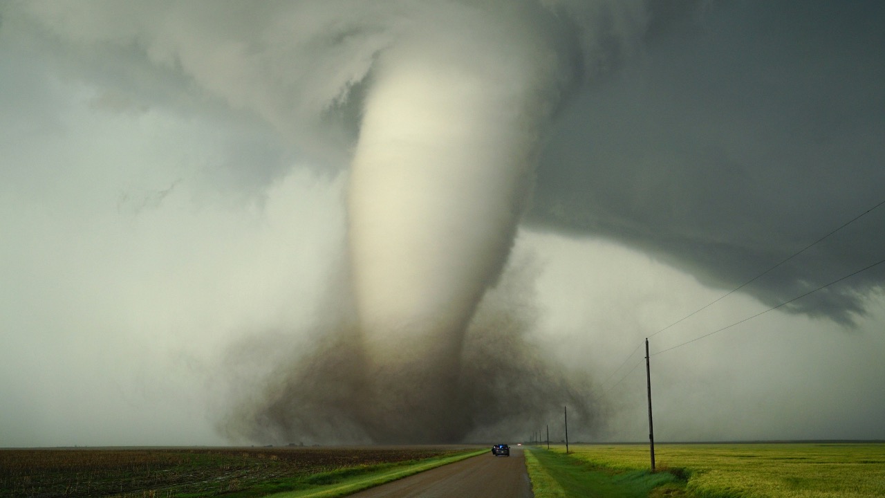
Models Signal Possible Severe Weather Outbreak in Florida Next Week, With Tornado Risk Highest Near Jacksonville
Computer models have been hinting at a shift in the pattern that could bring organized thunderstorms to parts of Florida next week. This setup involves increasing moisture from the Gulf combined with a frontal boundary sliding through the Southeast, creating conditions where storms might intensify quickly. Forecasters watch these signals closely because Florida’s spring transition often produces unpredictable severe weather, especially when wind shear aligns with unstable air.
You will want to stay alert as the details firm up. Computer guidance suggests the highest potential for rotation near the First Coast, where Jacksonville sits in a zone that could see the best overlap of ingredients. Pay attention to updates from the National Weather Service and local offices, as timing and exact placement can change.
Understanding the Setup

Atmospheric models point to a warm, humid air mass building across the state early next week. A disturbance moving from the west will interact with this moisture, allowing scattered storms to develop and possibly organize into lines or clusters. Wind profiles in the atmosphere could support some rotation, raising the chance for a few tornadoes, particularly in northeast Florida.
This kind of pattern is not unusual for late April into early May, when sea breezes and inland heating clash with incoming systems. Near Jacksonville, the proximity to the coast and potential for discrete cells before any linear mode takes over could elevate the tornado risk compared with other parts of the state. Keep an eye on afternoon and evening hours when instability peaks.
What the Models Are Showing
Guidance from several ensembles indicates a window of concern starting around Sunday into Monday, with storms possible from central Florida northward. Parameters like CAPE and shear values appear sufficient for strong updrafts, though confidence on widespread coverage remains moderate. The area around Jacksonville stands out in some runs because of better low-level flow.
You should treat these as signals rather than certainties. Models can adjust as new data arrives, so check reliable sources multiple times a day. The Storm Prediction Center will likely outline risk areas if the threat materializes, helping you gauge how seriously to prepare.
Risks to Watch For
Damaging winds and hail represent the most common threats in these setups, but a few tornadoes cannot be ruled out, especially if supercell structures form. Heavy rain could also lead to localized flooding in urban spots or low-lying areas. Jacksonville and surrounding communities may face the greatest concern for any rotating storms due to the forecast track.
Prepare your home and vehicle now. Secure loose outdoor items, review your emergency kit, and make sure you have ways to receive alerts even if power goes out. Knowing the difference between a watch and a warning gives you crucial time to act.
Timing and Placement
Storms would likely fire first in the afternoon as daytime heating ramps up, then spread or consolidate into the evening. Northeast Florida, including the Jacksonville metro, appears most exposed in current thinking, while southern areas might see more isolated activity. This timing aligns with when people are often commuting or outside, so situational awareness matters.
Monitor radar and official forecasts closely during the potential window. Conditions can evolve fast once storms develop, and warnings may come with little lead time for tornadoes.
How Florida’s Geography Plays a Role
The state’s peninsula shape and abundant moisture from surrounding waters often amplify storm development in transition seasons. Near Jacksonville, the St. Johns River and coastal influences can add localized spin or focus rainfall. These factors make the region prone to quick escalation when larger-scale systems arrive.
You benefit from living in an area with good radar coverage and experienced forecasters. Use that advantage by staying informed through local media and apps rather than waiting for alerts to reach you.
Preparation Steps You Can Take Now
Review your family’s severe weather plan and update contact numbers. Charge backup batteries and download offline maps. Identify the safest spot in your home, ideally an interior room on the lowest floor away from windows. For mobile homes or vehicles, know the nearest sturdy shelter.
Stock non-perishable food, water, and medications for several days. Flashlights, a weather radio, and cash can prove useful if services are disrupted. Taking these steps reduces stress when the atmosphere turns active.
Staying Safe During the Event
When storms approach, move indoors immediately and avoid windows. If a tornado warning is issued for your area, get to your safe space and stay there until the all-clear. Listen to local authorities for updates on road conditions or power outages after the system passes.
Afterward, watch for downed lines or flooding before venturing out. Report any damage to your local emergency management so resources can be directed where needed most. Recovery often goes smoother when everyone shares accurate information.
Long-Term Context for Florida Residents
Spring severe weather patterns come and go, but consistent preparation builds resilience. The models highlight another reminder that Florida’s climate supports strong storms even outside peak hurricane season. Jacksonville’s location puts it in the path of many such events over the years.
Use this outlook as motivation to refine your readiness year-round. Communities that practice good habits weather these episodes with fewer surprises and faster rebounds.

Asher was raised in the woods and on the water, and it shows. He’s logged more hours behind a rifle and under a heavy pack than most men twice his age.