The expanding ‘Gateway to Hell’ crater now visible from space
The so called Gateway to Hell in Siberia is no longer a rumor traded among geologists and bush pilots. The Batagaika Crater has grown into a 200 acre wide, 300 foot deep scar in the Yana highlands of Siberia, big enough that satellites now track its spread in detail. What started as a slump in a forested hillside has turned into one of the clearest, and most unsettling, signs of what happens when frozen ground that has held for tens of thousands of years begins to fail.
I have spent enough time on thawing tundra and rotten winter ice to know that when the ground itself starts to move, you pay attention. Batagaika is not only chewing through a hillside, it is unlocking ancient ice, long buried bones, and a lot of trapped greenhouse gas. The crater is growing fast enough to be measured from orbit, and the story it tells reaches far beyond one remote valley in the Yana Uplands.
From forested slope to collapsing megaslump

Long before anyone called it a gateway to anything, the site near the settlement of Batagay in the Yana Uplands was a cold, wooded slope. That changed when logging crews moved in and stripped the larch and birch that had shaded and insulated the permafrost since at least the Soviet era. Once the trees were gone, the dark, exposed soil absorbed more summer heat, the frozen ground beneath began to thaw, and in the 1970s a large section of hillside gave way, creating what scientists now describe as a thermokarst depression rather than a true impact crater, a feature often labeled Batagay or Batagaika in the technical literature.
The result is a sprawling slump that locals nicknamed a gateway to the underworld as it opened into the frigid landscape. Reporting on the region notes that the gateway sits in a belt of larch and birch woodlands that became a target of deforestation from the 1940s onward, setting the stage for the collapse. As the thaw front worked its way deeper into the slope, the initial slump widened and lengthened, turning into what researchers now call a permafrost megaslump, a kind of slow motion landslide driven not by rainstorms but by heat.
A 200 acre, 300 foot wound you can see from orbit
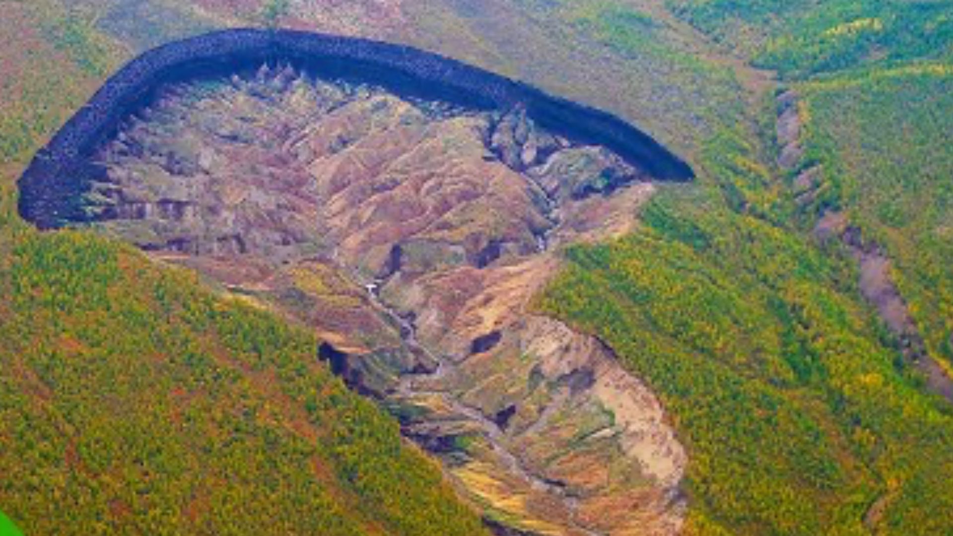
Today the Batagaika Crater is big enough that you do not need to stand on its rim to grasp its scale. Satellite images show a stingray shaped gash in the hillside, a 200 acre wide, 300 foot deep hole in the Yana highlands of Siberia that has become a reference point in climate science briefings and news reports alike. When you look at the overhead shots, the feature dwarfs the surrounding forest, its bare, slumping walls a stark contrast to the dark green of the remaining trees.
Ground based estimates of its footprint line up with what the satellites see, describing a depression that covers roughly 200 acres and drops about 300 feet from rim to floor in the heart of the Yana region of Siberia and is commonly referred to as the Batagaika Crater. Other measurements frame the chasm in more familiar backcountry terms, noting that it currently stretches about 0.6 miles long and 0.5 miles across, dimensions that match what you would expect from a medium sized alpine lake, except this basin is raw, collapsing earth rather than water.
Tripling in size and racing across the slope
The part that keeps scientists up at night is not only how big Batagaika is, but how quickly it is changing. Between 1991 and 2018, its size tripled, a growth spurt that lines up with the rapid warming of the Arctic, a region that is heating faster than any other place on Earth. Time lapse satellite records show the headwall marching uphill year after year, eating into intact permafrost and pulling the surrounding forest down with it.
Recent analyses put hard numbers on that motion, describing a kilometre wide crater that is growing at an alarming rate of around 30 m a year and expanding by roughly 35 m million cubic feet of thawing ground annually. One assessment notes that the formation is currently stretching about 0.6 miles long and 0.5 miles wide and that the slump is growing by 35 m million cubic feet each year, while another describes the dramatic Batagaika Crater as expanding by about 35 m million cubic feet annually. A separate study that tracked the feature over nearly three decades concluded that the crater will likely eat through the entire hillslope before it slows down and that it did not show any signs of stabilization, a warning that the process is still in full swing.
Why scientists say it is not really a crater
Despite the name that has stuck in headlines, what is happening at Batagay is not an impact crater in the classic sense. Geomorphologists classify it as a thermokarst depression, essentially a slump or hole formed by the melting of frozen ground that is rich in ice. When that ice melts, the soil above loses its support and collapses, creating steep headwalls and a chaotic floor pocked with ponds and gullies. In plain language, the ground is rotting from the inside out as the permafrost thaws.
Researchers who have walked the site describe Batagay, also referred to as Batagaika, as a textbook example of this process, with thawing permafrost carving out a megaslump rather than a clean bowl. One detailed account explains that Batagay is not a crater but a thermokarst depression, a slump or hole formed by the melting of frozen ground, and that the terrain consists of layers of waterlogged permafrost that began to fail after human disturbance. Another overview notes that the depression is in the permafrost zone and is currently growing in size, and that according to the authors of a study published in the journal Geomorphology, the crater will leak all of the remaining ground ice and carbon in the affected slope if the process continues.
Permafrost, deforestation and a human fingerprint
From a distance, it is easy to chalk Batagaika up to natural Arctic cycles, but the backstory points to a clear human trigger. The hillside that failed had been logged heavily, part of a broader push that turned the larch and birch woodlands of the Yana Uplands into a source of timber starting in the 1940s. Those trees were more than scenery. Their shade kept the ground cooler in summer, their roots helped hold the soil together, and their trunks trapped snow that insulated the permafrost in winter. Once they were cut, the slope was exposed to more sunlight and more runoff, and the frozen ground beneath began to thaw.
Accounts of the region emphasize that the gateway sits in a landscape of larch and birch woodlands that became the target of Deforestation from the 1940s onward, and that when it opened, the gateway to the underworld was a direct result of that hillside collapse. Another analysis of the megaslump notes that the formation of this mega slump is attributed to human activity, including deforestation that destabilized the slope and excessive surface warming that triggered permafrost melting once the crater formed, excessive melting triggering permafrost melting in a feedback loop. In other words, people set the conditions, and a warming climate did the rest.
Ancient ice, fossils and a 200,000 year archive
For all its menace, Batagaika is also a rare window into a buried world. As the headwalls retreat, they expose cross sections of permafrost that have been locked away since long before modern humans walked the region. Researchers believe the exposed ice and soil along the crater’s edges could hold up to 200,000 years of geological and biological history, a frozen archive of past climates, vegetation and wildlife. Each new collapse peels back another layer, revealing ancient ice wedges, buried soils and the remains of long vanished animals.
Field teams working along the slump walls have already reported finds that read like a Pleistocene field guide. One detailed description notes that sometimes described as resembling a stingray or a tadpole, the Batagaika Crater is a widening chasm in Siberia and the site where remains of an extinct horse species were found, along with other Ice Age fauna. Another overview of the site points out that the kilometre wide crater is Hiding Ice Age fossils and permafrost and that its walls expose some of the second oldest permafrost on Earth. A separate satellite based assessment notes that Researchers believe the exposed ice and soil along the crater’s edges could hold up to 200,000 years of records, with gullies dropping to Batagaika’s floor where meltwater carries away the debris.
Methane, carbon and a growing climate feedback
Every chunk of ground that slumps into Batagaika is more than dirt. It is frozen organic matter that has been locked away in permafrost for tens of thousands of years, and when that permafrost thaws, microbes wake up and start breaking it down, releasing carbon dioxide and methane. That is why climate scientists pay such close attention to features like this megaslump. They are not only responding to warming, they are feeding it, turning the ground into a slow but steady source of greenhouse gas.
Measurements from the region indicate that the amount of methane and carbon gases released into the atmosphere from the thawing permafrost has reached between 4,000 and 5,000 tonnes each year, a flow that adds to the broader Arctic carbon budget. One report on the expanding feature notes that scientists discovered the gateway to hell is expanding so quickly that the amount of methane and carbon gases released into the atmosphere has reached between 4,000 and 5,000 tonnes each. Another assessment warns that according to the authors of a study in According the journal Geomorphology, the crater will leak all of the remaining ground ice and carbon in the affected slope if the process continues, meaning the site is both a symptom and a driver of the warming that created it.
Satellites, tripled size and the view from space
From a hunter or trapper’s perspective on the ground, Batagaika is a dangerous place to walk. From orbit, it is a clean, measurable signal. Satellite platforms have been watching the slump since at least the early 1990s, and the before and after images are stark. Where there was once a modest scar in the hillside, there is now a sprawling, light colored gash that has tripled in size, its headwall pushing steadily upslope and its floor filling with thaw ponds and debris fans.
One set of satellite comparisons shows the expansion of the Batagaika Crater between 1991 and 2024, noting that sometimes described as resembling a stingray or a tadpole, the Batagaika Crater is a widening chasm in Siberia and the world’s largest permafrost megaslump, with its outline changing year by year. Another remote sensing overview explains that between 1991 and 2018, the crater tripled in size due to warming in the Arctic, a region experiencing faster temperature increases than any other place on Earth, and that between 1991 and 2018 its size tripled as thawing permafrost, initially triggered by deforestation during the Soviet era, is the primary cause of this expansion. High resolution imagery from European missions adds that this kilometre wide crater is Gateway to Hell in popular coverage, a feature now large enough to be a regular target for Earth observation campaigns.
What Batagaika tells the rest of us
Standing on the rim of a feature like this, you feel small. You also feel the ground under your boots and wonder how solid it really is. For people who live and work in the north, thawing permafrost is not an abstract graph. It is a cabin foundation that suddenly tilts, a winter road that buckles, a riverbank that slumps into the current. Batagaika is the extreme version of that story, a place where all the forces at work in the Arctic are concentrated in one collapsing slope.

Asher was raised in the woods and on the water, and it shows. He’s logged more hours behind a rifle and under a heavy pack than most men twice his age.