Why scientists are racing to understand collapsing glaciers
Glaciers are failing in real time, and the pace is starting to outrun the science that explains it. Nowhere is that more obvious than at Antarctica’s so‑called Doomsday Glacier, where ice the size of countries is cracking, thinning, and sliding toward the sea. The race to understand these collapsing giants is not academic; it is about how much coastline the world can keep and how fast communities will have to move.
Scientists are throwing everything they have at the problem, from hot‑water drills to seal‑mounted sensors, because the physics playing out at a few remote glaciers will help decide future sea levels for generations. I see it as one of the clearest stress tests of how quickly we can read a changing planet and react before the water is at our knees.
Why one glacier has the world’s attention
Out of all the ice on the planet, Thwaites Glacier in West Antarctica has become the main character in this story. It is huge, roughly the size of Florida, and it sits in a position that helps hold back a much larger section of the West Antarctic ice sheet. Researchers tracking its retreat describe it as one of the fastest changing glaciers on the continent, a slab of ice that is already contributing noticeably to global sea level and could unlock far more if it destabilizes. That is why so much of the current work on collapsing glaciers keeps circling back to this one.
Field campaigns and satellite data show that Thwaites is not only thinning at the surface, it is being attacked from below where it meets the ocean. Warmer water is reaching the grounding line, the point where the glacier lifts off the bedrock and starts to float, and that undercutting is helping fractures race inland. Detailed profiles of the glacier’s shape and flow from projects like the Thwaites research program have turned it into a kind of laboratory for understanding how fast a big marine glacier can unravel and what that means for the rest of the ice sheet behind it.
The mechanics of a collapsing glacier
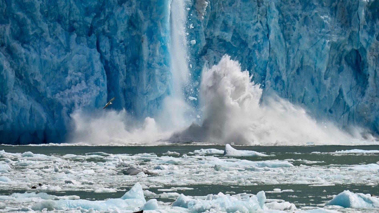
When people picture a glacier failing, they usually imagine a cliff of ice breaking off into the sea. The real mechanics are more complicated and more worrying. At Thwaites and similar glaciers, the floating ice shelf that acts like a brace is thinning and cracking, which lets the inland ice speed up. Once that buttress weakens enough, the glacier can retreat rapidly along a sloping bed, a setup that glaciologists call marine ice sheet instability. That is the kind of runaway behavior scientists are trying to pin down before it is fully underway.
On the seafloor in front of Thwaites, sonar and drilling work show deep channels that funnel relatively warm water toward the grounding line, where it can melt the glacier from below and pry it off its bed. Observations of Warmer ocean currents altered by climate change reaching that contact zone help explain why the ice is eroding so quickly there. Once the grounding line starts to retreat into deeper basins, the glacier can pick up speed, and the collapse shifts from a slow leak to something closer to a structural failure.
How much water is really at stake
For coastal hunters, anglers, and anyone who lives near sea level, the key question is not the exact shape of the grounding line, it is how much water ends up in the ocean and when. Thwaites on its own holds enough ice to raise global sea levels by on the order of two feet, but its real punch comes from what it is holding back. If it destabilizes the larger West Antarctic ice sheet, scientists estimate that sea levels could eventually climb by 10 to 15 feet, a change that would redraw shorelines on every continent and swamp low‑lying deltas, marshes, and barrier islands that support fish and waterfowl. That is why researchers describe it as a gatekeeper for a much larger store of ice.
Even before any worst‑case collapse, the glacier is already a major player in today’s sea level budget. The Thwaites is retreating rapidly due to climate change and already accounts for about 4 percent of sea level rise on Earth, losing roughly 50 billion tons of ice each year. If it collapses entirely, it could eventually drive around 65 cm of sea level rise on its own, and for every centimetre of sea level rise, around one million additional people are exposed to coastal flooding according to recent analysis. That is the kind of math that keeps this glacier at the center of every serious sea level discussion.
The international race to study Thwaites
To get ahead of those numbers, researchers have built one of the most ambitious polar science efforts ever attempted. The International Thwaites Glacier Collaboration, often shortened to ITGC, is a multi‑year project that brings together more than 60 scientists from several countries, with the United States and the British Antarctic Survey playing central roles. Their goal is straightforward and urgent: figure out why this glacier is changing so fast, how stable it really is, and what that means for future sea level rise. I see it as a kind of crash investigation, except the wreck is still in progress.
Teams working under the ITGC umbrella are mapping the seafloor, drilling through hundreds of meters of ice, and installing GPS and radar instruments across the glacier’s surface. One branch of the work focuses on the ice shelf and grounding line, another on the geology and sediments beneath the ice, and others on the ocean currents that feed warm water into the cavity under the shelf. Reporting on the project notes that the International Thwaites Glacier is designed to pull all of that into a single picture, so that models of the glacier’s future are grounded in real measurements instead of guesswork.
Listening for seismic “thunder” in the ice
One of the more striking tools in this race is essentially eavesdropping on the glacier. As Thwaites flexes, cracks, and grinds across its bed, it sends out tiny earthquakes that can be picked up by sensitive seismometers. Researchers like Willet and her team have been using those instruments to detect what they describe as seismic thunder, a constant background of pops and rumbles that reveal where the ice is fracturing and how stress is shifting deep inside the glacier. It is a way to watch the failure process from the inside out, even in the long polar night when satellites and field crews are limited.
Those seismic signals, combined with GPS and radar, are feeding into models that try to bracket how long the glacier’s remaining ice shelf can hang on. Some recent work suggests that a full collapse of the glacier’s marine portion may take hundreds to a few thousand years, but the same studies warn that localized failures and rapid retreats along certain troughs could happen much sooner. Coverage of this work on Full collapse timelines stresses that the West Antarctic Ice Sheet (WAIS) as a whole is vulnerable once key glaciers like Thwaites start to let go. For anyone who spends time on the coast, that long tail of risk matters less than the near‑term acceleration that could show up within a human lifetime.
Warm water, feedback loops, and a “Doomsday” nickname
Under all the technical work sits a simple driver: heat. Warm ocean currents are now reaching parts of Antarctica that used to be locked in cold, and those currents are chewing away at the undersides of glaciers. At Thwaites, an international team has documented a feedback loop where new cold water from the melting ice shelf mixes with warmer deep water, which then continues to erode the ice from below. That churning helps open up more cavities and channels, which in turn let even more warm water in. It is the kind of self‑reinforcing cycle that earns a glacier a nickname like Doomsday.
Recent reports describe how this feedback is already visible in the way crevasses and rifts are growing around a shear zone in the ice, a region where different parts of the glacier slide past each other at different speeds. As the ice shelf thins and fractures, its ability to hold back the inland ice weakens, and the whole system becomes more sensitive to small changes in ocean temperature. The international team that flagged this process warned that the glacier is approaching a potentially catastrophic collapse, language that has been echoed in both scientific briefings and more general coverage of the Doomsday glacier. A companion report highlighted how fractures are starting to grow around that shear zone, a visible sign of the internal stresses that could eventually tear the shelf apart, as described in follow‑up coverage of the same collapse risk.
What drilling, seals, and hot water are revealing
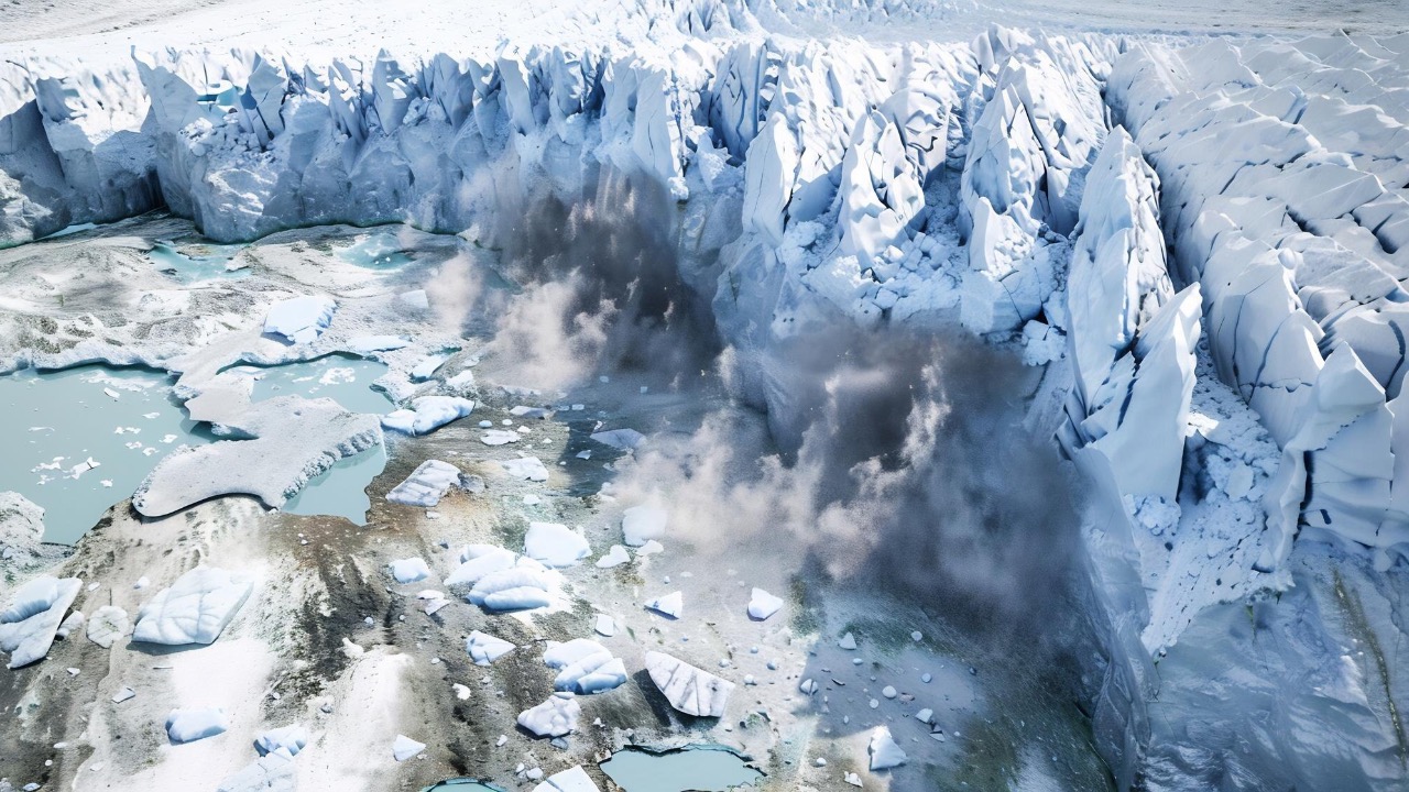
To really understand those feedbacks, scientists have had to get under the ice, not just look at it from space. On recent expeditions, teams have used hot‑water drills to punch narrow holes through hundreds of meters of ice so they can lower instruments into the ocean cavity below. Those tools measure temperature, salinity, and currents, and they can even scan the underside of the ice shelf to see where melt rates are highest. One report described how warm ocean currents are eroding the glacier from below and weakening the ice shelf that acts like a brace, a pattern confirmed by crews who are drilling into the ice to understand what is really happening.
Scientists have also turned to some unlikely field assistants. Seals that naturally dive along the glacier’s front have been fitted with small sensors that record temperature and depth as they hunt, then beam that data back when they surface. Those animal‑borne instruments have helped fill in gaps in the ocean record during bad weather and polar night, giving researchers a better picture of how warm water pulses in and out of the cavity. Reporting on these efforts notes that the same teams are racing to collect as much data as they can before the glacier’s front becomes too broken and dangerous to work near, a point underscored in coverage of how scientists are racing to study Antarctica’s Doomsday Glacier before it is too late.
Beyond Antarctica: Greenland and the bigger ice story
Thwaites gets the headlines, but it is not the only ice system that has scientists on edge. Greenland’s ice sheet, which holds enough frozen water to raise sea levels by several meters, is also showing signs that parts of it could be closer to tipping points than earlier models suggested. Researchers studying Greenland’s ice cores describe them as a backbone of our understanding of past climate swings, because they record seasonal variations in snowfall and temperature that line up with known hot and cold periods. Those records show that the ice sheet has responded quickly to past warming, a warning sign for what continued greenhouse gas emissions could trigger in the future.
New work on Greenland’s melt patterns suggests that some outlet glaciers there may also be vulnerable to warm ocean water and feedback loops similar to what is being seen in West Antarctica. The concern is that if both major ice sheets start to lose mass more rapidly at the same time, the combined effect on sea level could outpace the ability of coastal communities to adapt. Coverage of these findings in Greenland’s ice sheet collapse risk emphasizes that the ice cores are not just historical curiosities, they are a warning label for what happens when the climate system is pushed too far.

Asher was raised in the woods and on the water, and it shows. He’s logged more hours behind a rifle and under a heavy pack than most men twice his age.